Picture this: you’re managing customer experience for a global supply chain company. Suddenly, your operations team alerts you about potential disruptions in Southeast Asia. However, traditional monitoring systems provide limited visibility into environmental factors affecting your customers’ deliveries. This scenario illustrates why groundbreaking missions like NISAR matter for modern customer experience professionals.
What Makes NISAR Different for CX Leaders?
The NASA-ISRO Synthetic Aperture Radar satellite launches July 30, 2025, from Sriharikota at 5:40 PM IST. Moreover, this mission represents something revolutionary for customer experience management. Unlike previous Earth observation satellites, NISAR combines dual-frequency radar technology with unprecedented coverage capabilities.
First, let’s understand the scale. NISAR weighs 2,392 kilograms and measures about the length of a pickup truck. Additionally, it operates from a sun-synchronous polar orbit at 747 kilometers altitude. The satellite completes Earth coverage every 12 days while sampling most locations every 6 days.
Furthermore, the mission emerged from the 2007 National Academy of Sciences decadal survey. Subsequently, NASA and ISRO formalized their partnership on September 30, 2014. This collaboration leverages complementary expertise from both space agencies.
Revolutionary Technology That Impacts Customer Operations
Now, let’s examine the technical specifications that matter for CX applications. NISAR features the world’s first dual-frequency Synthetic Aperture Radar system. Specifically, NASA provides L-band radar operating at 1.257 GHz frequency. Meanwhile, ISRO contributes S-band radar functioning at 3.2 GHz frequency.
The L-band system penetrates deep vegetation and provides landscape topography data. Conversely, the S-band system monitors light vegetation and coastal processes effectively. Together, these systems create comprehensive environmental intelligence.
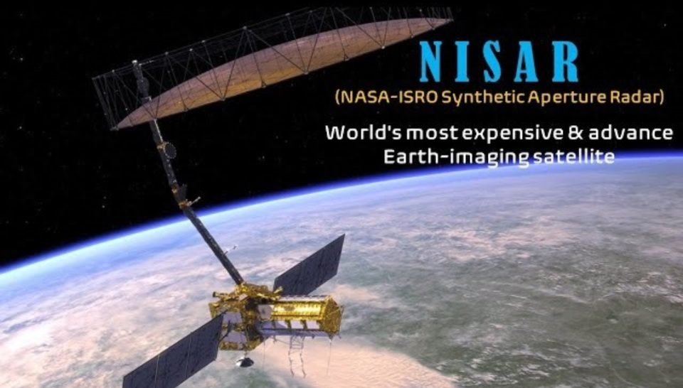
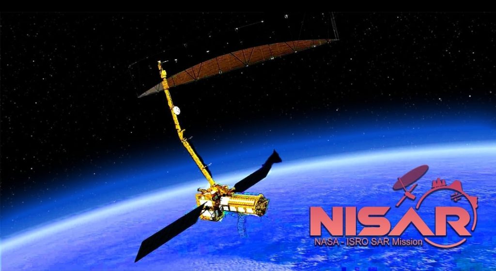
Additionally, NISAR employs a 12-meter deployable mesh reflector antenna. This gold-plated wire mesh represents NASA’s largest ever launched antenna system. The reflector mounts on a 9-meter boom and serves both radar systems simultaneously.
Most importantly, NISAR introduces SweepSAR technology to space-based operations. This innovation transmits using all array elements while sweeping the beam across the reflector. Consequently, the system achieves simultaneous wide-swath coverage exceeding 240 kilometers with 3-10 meter resolution.
Primary Applications Transforming Customer Experience Management
The satellite addresses three fundamental domains that directly impact customer operations. First, solid earth dynamics monitoring tracks earthquake cycles and volcanic deformation. This capability enables proactive customer communication during natural disasters.
Second, ecosystem monitoring tracks forest biomass changes and agricultural productivity. Therefore, companies can anticipate supply chain disruptions before they affect customer deliveries. The system also monitors wetland variations and permafrost ecosystem changes.
Third, ice dynamics research studies glacier retreat and polar ice movement patterns. This data helps predict long-term environmental changes affecting global operations.
Furthermore, NISAR provides millimeter-level accuracy for surface deformation detection. Such precision enables infrastructure monitoring for dams, bridges, and urban areas. Companies can therefore assess risks to facilities serving key customer segments.
Data Revolution: 80 Terabytes Daily for Strategic Insights
NISAR generates 80 terabytes of data products daily—more than any previous Earth satellite. This massive dataset requires innovative cloud-based processing and distribution systems. However, the volume creates unprecedented opportunities for customer experience analytics.
The mission produces structured data products across multiple levels. Level-0 contains raw radar signal data for specialized applications. Level-1 includes Single Look Complex and Multi-Look Detected imagery. Level-2 provides geocoded Level-1 products for geographic analysis.
Meanwhile, Level-3 offers large area radiometric terrain corrected mosaics. Level-4 delivers science products in physical units for direct business applications.
Most significantly, NISAR maintains a comprehensive open data policy. All science data from both radar systems becomes freely available to the global community. NASA distributes data through the Alaska Satellite Facility Distributed Active Archive Center. Similarly, ISRO provides access through its Bhoonidhi portal.
Data becomes available 1-2 days after observation for routine applications. Emergency data reaches users within hours during crisis situations. This rapid availability enables real-time customer experience management during disruptions.
Overcoming Development Challenges for Enhanced Reliability
The mission faced several technical challenges throughout its development journey. Initially, COVID-19 caused 7-month delays and $36 million additional costs during 2021. Subsequently, 12-meter antenna reflector issues required return to NASA for thermal coating upgrades.
However, these challenges ultimately enhanced system reliability and performance capabilities. The development team resolved complex integration issues between dual-frequency radar systems. Additionally, they perfected the revolutionary SweepSAR technique for space-based operations.
Final integration completed at ISRO’s Bengaluru facility during 2024. The satellite underwent encapsulation in its payload fairing on July 18, 2025. These preparations ensure optimal performance for customer-critical applications.
Transformative Applications for Modern Customer Experience
NISAR’s capabilities translate into specific customer experience improvements across multiple industries. For disaster response, the system provides real-time tracking of earthquakes and volcanic eruptions. Companies can therefore implement proactive customer communication strategies during emergencies.
Early warning systems enable infrastructure monitoring for critical customer touchpoints. Rapid damage assessment following catastrophic events supports faster service restoration. These capabilities minimize customer disruption during crisis situations.
Climate monitoring applications track environmental indicators affecting long-term customer planning. Glacier monitoring provides sea level projections for coastal facility planning. Ecosystem health assessment supports sustainability initiatives that customers increasingly value.
Agricultural monitoring enables crop assessment and irrigation planning for food industry clients. Soil moisture data supports precision agriculture initiatives affecting supply chain reliability. Water resource management applications help utilities maintain consistent customer service levels.
Operational Excellence Through Advanced Earth Intelligence
NISAR’s 90-day commissioning period begins immediately after launch completion. Subsequently, the satellite starts its primary science mission with comprehensive Earth scanning capabilities. The system covers Earth’s surface every 12 days through ascending and descending passes.
Overlapping coverage patterns provide location sampling approximately every 6 days on average. Left-looking mode operations maintain precise pointing control within 273 arcseconds accuracy. Wide-swath coverage exceeding 240 kilometers ensures comprehensive regional monitoring.
Multiple resolution modes accommodate different customer application requirements. High-resolution 3-meter imagery supports detailed infrastructure monitoring. Medium-resolution 10-meter data enables broad area environmental assessment.
Strategic Partnership Model for Global Customer Success
The NASA-ISRO collaboration demonstrates effective international partnership strategies for customer-focused organizations. Both agencies contribute complementary expertise while maintaining independent operational capabilities. This model enables comprehensive global coverage without duplicating infrastructure investments.
ISRO focuses on Indian subcontinent monitoring and specific regional science requirements. NASA provides global operations coverage supporting worldwide customer needs. Together, they create a comprehensive Earth observation system serving diverse customer segments.
The partnership also establishes precedents for future international space cooperation initiatives. Such collaborative approaches enable cost-effective solutions for global customer experience challenges.
Future Implications for Customer Experience Innovation
NISAR represents more than technological advancement—it embodies a new paradigm for data-driven customer experience management. The mission’s comprehensive monitoring capabilities provide unprecedented environmental intelligence for business operations.
Revolutionary dual-frequency radar technology establishes new standards for Earth observation accuracy. SweepSAR innovation enables simultaneous wide coverage with high resolution imaging. Open science commitment ensures broad accessibility for customer experience applications.
Success demonstrates the power of international partnerships in addressing global customer challenges. The mission strengthens foundations for future collaborative space initiatives. Moreover, it establishes frameworks for integrating space-based intelligence into customer experience strategies.
NISAR will advance scientific understanding while providing practical tools for customer experience professionals. Its success proves that innovative partnerships can deliver transformative capabilities for global customer success. Therefore, organizations should prepare to leverage these unprecedented Earth observation capabilities for enhanced customer experience management.